
Previously I attempted to show that there are multiple feedback mechanisms which are capable of causing a composite positive feedback effect in which Arctic sea ice once reduced beyond a limit will disperse very rapidly and will fail to recover.
Since I published that Article - April 29 2010 - I have investigated the matter further. Current satellite data and historical reports combine to suggest that this year's Arctic sea ice loss will be the greatest ever seen in human history.
Throughout human history the North West and North East Passages have been traps for ships and killers of men. Prior to 2000 none of the passages was ever open from end to end. The ice which blocks these passages once melted is - by definition - first year ice, hence easily melted. That is a positive feedback.
This summer, the Royal Canadian Mounted Police patrol vessel Nadon (temporarily rechristened the St Roch II) made a transit through the Northwest Passage — the shortcut between the Pacific and the Atlantic across the top of North America — and encountered very little sea ice along the way.
Nature 408, 634-636 (7 December 2000) | doi:10.1038/35047263
http://www.nature.com/nature/journal/v408/n6813/full/408634a0.html
Jan Mayen and the Odden Ice Tongue
The Odden Ice Tongue used to form between Greenland and the tiny island of Jan_Mayen, about halfway between Iceland and Svalbard. It has not been seen since 1997.
Jan Mayen Island and Beerenberg
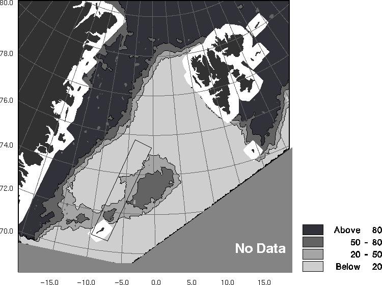
The Odden was most extensive in 1979, 1982, 1986, and 1997 and most persistent in 1988, 1989, and 1997 but did not appear in 1984, 1994, and 1995, suggesting decadal periodicity for the 20 year period.
http://www.agu.org/pubs/crossref/2001/2000JC000204.shtml
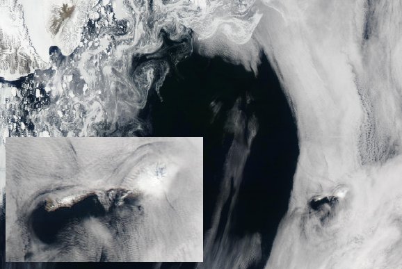
Odden Ice Tongue February 16, 1993
Image source: http://earth.esa.int/...
The Odden Ice Tongue was a seasonal bridge of ice from the Greenland coast to Jan Mayen Island, with an extended tongue beyond. The tongue had two modes of formation. The normal mode formed sea ice directly, rejecting salt into the ocean and driving part of the return circulation of the Atlantic conveyor. A second mode formed a bridge of mainly older ice, rejecting less salt into the ocean.
Both modes obstructed the egress of broken ice from the main ice cap via the Fram Strait. The loss of the Odden has allowed warm water to flow further north and has removed an obstacle to ice loss by southerly drift. The loss of the Odden is a double feedback.
The Nares Polynya
I wrote extensively about the Nares Polynya in Arctic Tipping Points - #4: The Broken Bridges Of Nares. Here I present more images of the Nares ice bridges in past years and images of the current state of the ice in that region.
The sequence of images below is taken from Rapidfire images 2002 to 2009

July 19 2002 - ice blockages in Nares Strait..
http://rapidfire.sci.gsfc.nasa.gov/realtime/single.php?2002200/crefl1_14...
August 30 2003 - slow ice export from Lincoln Sea into Nares Strait.
http://rapidfire.sci.gsfc.nasa.gov/realtime/single.php?2003242/crefl1_14...
July 30 2004 - two ice bridges block the strait.http://rapidfire.sci.gsfc.nasa.gov/realtime/single.php?2004182/crefl1_143.A2004182205001-2004182205501.1km.jpg
July 01 2005 - entire strait blocked by ice bridges and ice jams.http://rapidfire.sci.gsfc.nasa.gov/realtime/single.php?2005182/crefl1_143.A2005182224001-2005182224500.1km.jpg
July 01 2006 - Nares Strait almost entirely blocked by ice bridges and ice jams.
http://rapidfire.sci.gsfc.nasa.gov/realtime/single.php?2006182/crefl1_14...
July 13 2007 - ice begins to flow freely from Lincoln Sea.
http://rapidfire.sci.gsfc.nasa.gov/realtime/single.php?2007194/crefl1_14...
Note: most of the ice in left of image is from Kane Basin, not the Lincoln Sea.
July 01 2008 - most of the ice in the Nares Polynya is not from Lincoln Sea.
http://rapidfire.sci.gsfc.nasa.gov/realtime/single.php?2008183/crefl2_14...
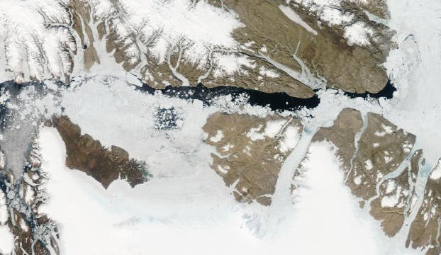
July 01 2009 - a strong ice arch keeps the polynya virtually ice free.
http://rapidfire.sci.gsfc.nasa.gov/realtime/single.php?2009182/crefl1_14...
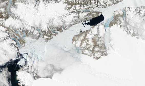
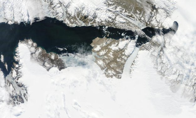
Nares Polynya 2010
There is a great deal of variability in the above images, all of which are from July, or later where July images are not available. The images below, from June 22 2010 show how much more readily the ice is flowing from Lincoln Sea to Baffin Bay this year. The flow is faster and earlier.
June 22 2010 - ice flows freely from Lincoln Sea to Baffin Bay
This resized image was taken from two images stitched together:
http://rapidfire.sci.gsfc.nasa.gov/subsets/?subset=Arctic_r03c02.2010173...
http://rapidfire.sci.gsfc.nasa.gov/subsets/?subset=Arctic_r03c03.2010173...
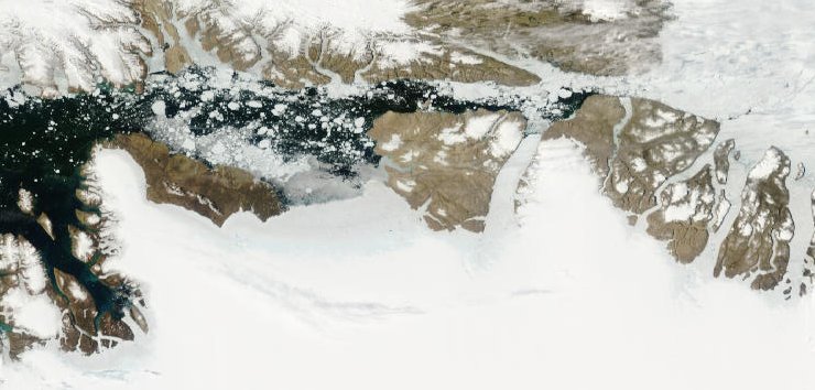
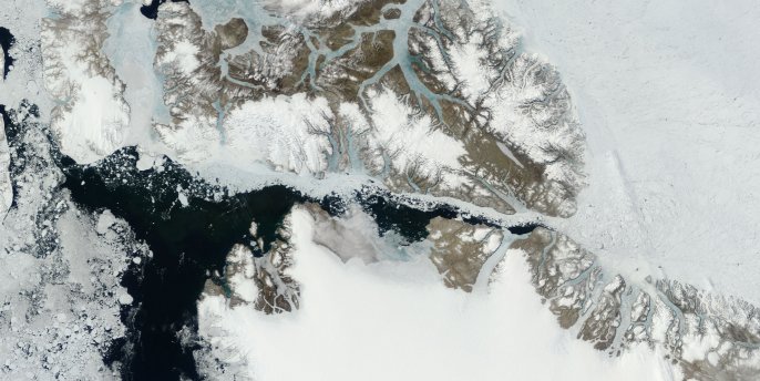
The image below shows the granularity and mobility of the ice in greater detail. Smaller floes make for an easier exit from the Arctic ice cap via Lincoln Sea and the Nares Polynya.
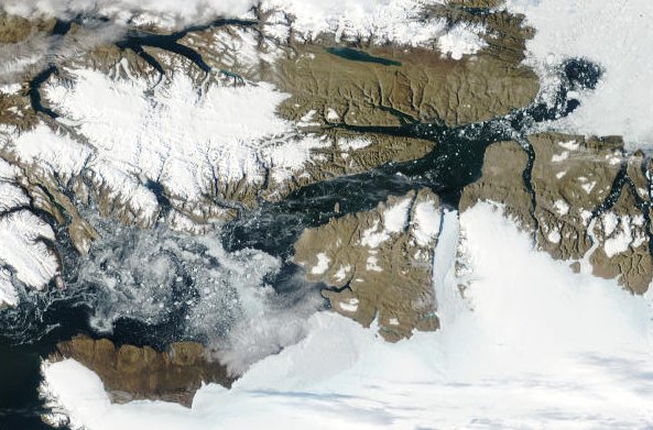
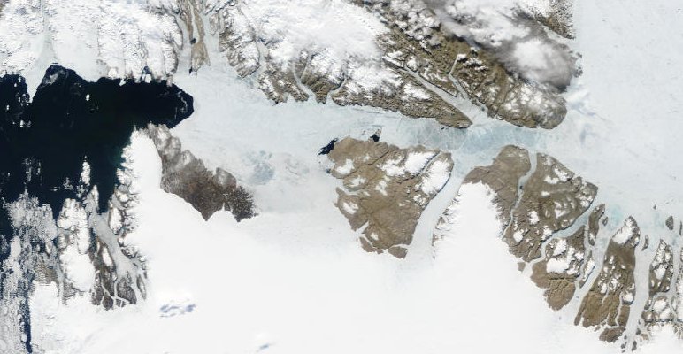
June 22 2010 - Nares Strait and Petermann Glacier
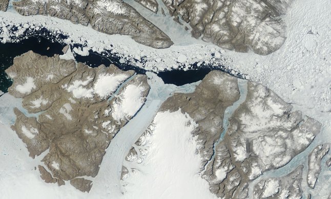
The Petermann Glacier ice tongue has a notched end and is not firmly attached to the walls of the fjord. The next image shows more detail of the mélange - mixed bergs and sea ice - and the melt pools.
Petermann Ice Tongue detail
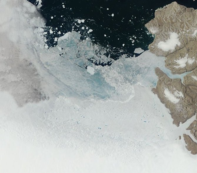
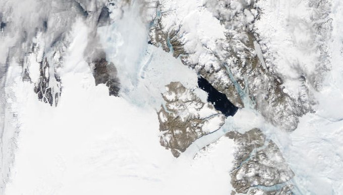
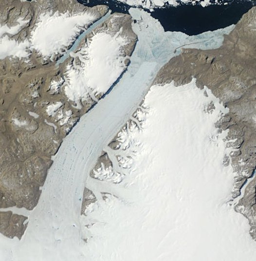
Humboldt Glacier and Kane Basin detail.At the bottom of the image is the Greenland ice cap. The ice cap margin is specked with meltwater pools. The blue area is sea ice, with speckles of white showing icebergs from the main calving front. To the left of that calving front the line of the glacier rarely changes. I consider it likely that the ice sheet is grounded on rock which slopes up towards Kane Basin, except at the calving front. Note the jagged lumps of ice, in contrast to the more rounded and granular sea ice in the other images.
Ice which appears in satellite images as blue areas separated by white lines - I like to call it 'panel ice' - seems to be more robust than other ice. Sea ice is often a mass of granular floes held together by new ice. Predictably the new ice will melt or fracture first, rendering the whole ice mass highly mobile. Panel ice tends to remain immobile longer than granular ice, and when it fractures it does so unpredictably.
Some points for discussion:
Historically, the main Arctic ice cap was less granular and less mobile.
Loss of multi-year ice was restricted by the Nares ice bridges and the Odden ice tongue.
Loss of some multi-year ice is part of the natural Arctic ice cycle. Ice loss creates gaps in which new ice can form. The formation of new ice and the rejection of brine from young ice drive the thermohaline circulation. Ice free summers may well alter thermohaline circulation patterns.
In summer, the presence of sea ice can, by acting as an insulator, produce a temperature difference between air and ocean of up to 30oC.
An ice free Arctic would produce air and sea temperatures substantially higher than normal.
Before ice can form, the sea and air temperatures must drop: the summer heat must be radiated away. After an ice free summer the Arctic winter freeze season will be shortened.
Snow increases the albedo of ice and acts as a thermal blanket. This delays ice melt in spring. Before Arctic snow can settle, it needs ice to settle onto. A delay in freezing brings a delay in snow cover. After an ice free summer, ice will be thinner and will have thinner snow cover than normal. This is another positive feedback.
Conclusion:
The loss of multi-year ice, the loss of the Odden ice tongue, the open Nares Strait, the granularity and mobility of the main ice cap: these factors taken together point to the likelihood that the Arctic has passed a tipping point with no realistic prospect of recovery.
A warmer Arctic will mean a greater summer loss of ice from Greenland's many glaciers..
References:
Odden Ice Tongue
Two modes of appearance of the Odden ice tongue in the Greenland Sea
http://ntrs.nasa.gov/archive/nasa/casi.ntrs.nasa.gov/19990009390_1998435...
http://www.nature.com/nature/journal/v408/n6813/full/408634a0.html
http://www.agu.org/pubs/crossref/2001/2000JC000204.shtml
http://www.sciencedirect.com/science?_ob=ArticleURL&_udi=B6VGC-3X7MKH9-8...
Nares Polynya
Ice Regime and Ice Transport in Nares Strait, Moira Dunbar
http://pubs.aina.ucalgary.ca/arctic/Arctic26-4-282.pdf
On checking the link, I found the file is now corrupt. I have posted a copy here:
Arctic26-4-282.pdf
Fall Ice Drift in Nares Strait, as Observed by Sideways-Looking Radar, Moira Dunbar
http://pubs.aina.ucalgary.ca/arctic/Arctic32-4-283.pdf
On checking the link, I found the file is now corrupt. Unfortunately I don't have a copy.
Evidence for atmospheric control of sea-ice motion through Nares Strait
http://www-hce.coas.oregonstate.edu/~rms/ms/NaresStraitGRLsubm_rev.pdf
Nares Strait Hydrography and Salinity Field ...
http://www.earth.ox.ac.uk/~helenj/work/publications/Berit1.pdf
to be continued...
No comments:
Post a Comment