
First is from Arctic Regional Ocean Observing System (Arctic ROOS)
Date: August 9, 2010 - open passage - this is over a month earlier than the below announcement.
http://www.iup.uni-bremen.de:8084/amsredata/asi_daygrid_swath/l1a/n6250/2010/aug/asi-n6250-20100809-v5_nic.png

Next is the Naval Ice Center announcement on September 19, 2010
http://www.natice.noaa.gov/pr_20100920_northwest_passage_opening.html

Figure 1: Shows an Annotated Image of ENVISAT (©European Space Agency) and RADARSAT (©MDA), and MODIS of the Northwest Passage Sea Route Opening as analyzed on September 20, 2010.
(Click on the image above to view the full-sized 1100 x 850 image.)
September 20, 2010, Washington, DC — September 20, 2010, the National Ice Center (NIC) identified the opening of the Northwest Passage through the Arctic. RADARSAT, ENVISAT, and MODIS imagery from the 18-20 of September, 2010, depicts only trace amounts of multi-year ice remaining in the Northwest Passage. Although the satellite imagery shows the area as "open water", conditions such as water on top of the ice, currents, winds and waves may obscure multi-year ice drifting in the area, and hazardous remnants of the older ice may still pose a threat to shipping.
The National Ice Center is a tri-agency operational center represented by the United States Navy (Department of Defense), the National Oceanic and Atmospheric Administration (Department of Commerce), and the United States Coast Guard (Department of Homeland Security). The National Ice Center mission is to provide the highest quality strategic and tactical ice services tailored to meet the operational requirements of U.S. national interests and to provide specialized meteorological and oceanographic services to United States government agencies. The National Ice Center, along with the Canadian Ice Service will continue to monitor the opening.
For more information, please contact:
Public Affairs Officer
National Ice Center
Naval Ice Center
Liaison
E-mail: LIAISON_WEB
If you have any comments or suggestions, please E-mail the National Ice Center Public Affairs Officer.
Overview of conditions
Average ice extent for September 2010 was 4.90 million square kilometers (1.89 million square miles), 2.14 million square kilometers (830,000 square miles) below the 1979 to 2000 average, but 600,000 square kilometers (230,00 square miles) above the average for September 2007, the lowest monthly extent in the satellite record. Ice extent was below the 1979 to 2000 average everywhere except in the East Greenland Sea near Svalbard.
The U.S. National Ice Center declared both the Northwest Passage and the Northern Sea Route open for a period during September. Stephen Howell of Environment Canada reported a record early melt-out and low extent in the western Parry Channel region of the Northwest Passage, based on analyses of the Canadian Ice Service. Two sailing expeditions, one Norwegian and one Russian, successfully navigated both passages and are nearing their goal of circumnavigating the Arctic.
National Snow and Ice Data Center FAQ: http://nsidc.org/arcticseaicenews/faq.html
Are there other sources of sea ice data? How do these sources differ from NSIDC data?
Other researchers and organizations monitor sea ice independently, using a variety of sensors and algorithms. While these sources agree broadly with NSIDC data, extent measurements differ because of variation in the formulas (algorithms) used for the calculation, the sensor used, the threshold method to determine whether a region is “ice-covered,” and processing methods. NSIDC's methods are designed to be as internally consistent as possible to allow for tracking of trends and variability throughout our data record. Links to other sources of sea ice data are listed below:
- University of Bremen Daily Updated AMSR-E Sea Ice Maps: http://www.iup.uni-bremen.de:8084/amsr/amsre.html
- IARC-JAXA Arctic Sea-Ice Monitor by AMSR-E: http://www.ijis.iarc.uaf.edu/cgi-bin/seaice-monitor.cgi
- University of Illinois Cryosphere Today: http://arctic.atmos.uiuc.edu/cryosphere/
- Nansen Environmental & Remote Sensing Center Arctic Regional Ocean Observing System: http://arctic-roos.org/observations
Another source of sea ice data is the operational centers that provide support to ships navigating in the Arctic. There are often discrepancies between information from these centers and our data because they employ additional data sources to capture as much detail on sea ice conditions as possible. However, unlike our data, because the quality and availability of their data sources vary, their products do not provide a long-term, consistent timeseries suitable for tracking climate trends and variability. Several Arctic nations have operational sea ice centers. The two North American centers are:
- U.S. National Ice Center: http://www.natice.noaa.gov/
- Canadian Ice Service: http://ice-glaces.ec.gc.ca/
Who are you going to believe? 30 days difference is unacceptable - I'm asking the U.S. National Ice Center (NOAA) to comment.
Standby for updates.
The ocean
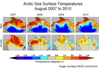
As in recent years, sea surface temperatures this summer were higher than normal in much of the Arctic Ocean, according to researchers at the University of Washington. Mike Steele, Wendy Ermold, and Ignatius Rigor found that temperatures in the Beaufort/Chukchi Seas and the region north of the Laptev Sea were particularly high. The high sea surrface temperatures resulted largely from the loss of sea ice: dark open water areas absorb more solar radiation than reflective ice. The warmer water in turn helps to melt more sea ice. This positive feedback likely contributed to the ice loss through summer 2010, especially late in the season when surface melt had largely ceased.
Press Release
Last Update: September 13, 2010
Northern Sea Route Opening

September 13, 2010, Washington, DC — September 13, 2010, the National Ice Center (NIC) identified the opening of the Northern Sea Route through the Arctic. RADARSAT and ENVISAT imagery from the 12-13 of September, 2010, depicts only trace amounts of multi-year ice remaining in the Northern Sea Route. The Northeast Passage is historically the last hold-out of remaining multi-year ice affecting the Northern Sea Route. Although the satellite imagery shows the area as "open water", conditions such as water on top of the ice, currents, winds and waves may obscure multi-year ice drifting in the area, and hazardous remnants of the older ice may still pose a threat to shipping.
No comments:
Post a Comment